
Archive Record
Images
Metadata
Title |
The Area of Stonewall Jackson's Valley Campaign, March - June, 1862 |
Catalog Number |
17.12.011 |
Object Name |
Map |
Donor |
Found in Collection |
Scope & Content |
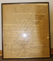
The Area of Stonewall Jackson's Valley Campaign, March - June, 1862. The Battlefields are Marked in Red and Blue. The map shows the route of General Thomas Jonathan "Stonewall" Jackson's Civil War campaign across the Alleghany Mountains and Blue Ridge Mountains. Charlottesville, Virginia, is the southernmost city shown. Martinsburg, West Virginia is the northernmost city shown. The map shows towns and battle sites along the Shenandoah River. Hand drawn unpublished map made and signed by Dr. John W. Wayland. Ink on butcher paper. 35.5 inches tall by 30 inches wide. In a wooden frame under glass. A note at the lower right corner indicates there is more information on the reverse of the map, but it is not accessible while framed. |
Creator |
Wayland, John Walter, 1872-1962 |
Collection |
Alexander Mack Memorial Library Special Collections |
Search Terms |
Jackson, Stonewall, 1824-1863 Shenandoah Valley Shenandoah Valley Campaign (1862) |
People |
Jackson, Stonewall, 1824-1863 Wayland, John Walter, 1872-1962 |
Subjects |
Jackson, Stonewall, 1824-1863 Shenandoah Valley Shenandoah Valley Campaign (1862) |